
textomap-2-0
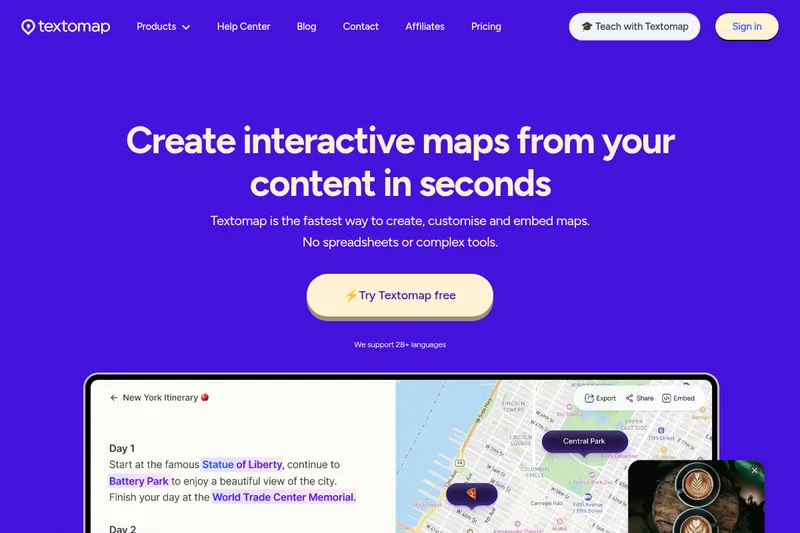
Textomap turns text, webpages, images, audio, CSV files, and prompts into interactive maps of detected locations. Educators, publishers, and travel teams can edit, share, embed, or export those maps.
One of 6 tools in Travel
Who it's for
- Educators who want students to explore geography, history, or science through maps made from class material.
- Content creators, bloggers, and news teams who want to add maps to articles or posts that mention locations.
- Travel agents and operators who want to map and share locations in itinerary content.
Not the right fit if…
- Teams importing more than 500 locations from a single CSV file: the page says only the first 500 locations will be imported.
- Users relying on the free plan for more than one embedded map or 10 map views: those are the stated free-plan limits.
How it fits your workflow
Choose a source type and provide text, a webpage link, an image, an audio file, a CSV, or a prompt. Textomap identifies locations and plots them on an interactive map.
Review and edit the map, including location details and pin presentation. Save it to share by link, embed it on a website, export it as CSV, or open it in Google Maps.
Pricing
Free: A free plan is available. The page states that free-plan users are limited to one embedded map and 10 map views; it also mentions account usage limits.
Free plan
Free; exact usage allowances may depend on the account limits shown in the product.
- · Create maps with the free plan.
- · Free-plan users are limited to one embedded map and 10 map views.
- · The page says ads are displayed to support the free service.
Paid plans
Paid plans are available; prices are not stated in the supplied content.
- · The page says paid plans unlock advanced features and higher map limits.
- · The Pro upgrade is described as ad-free and as unlocking all features.
Education plan
Price not stated in the supplied content.
- · The page describes an education offering with an individual account for every student.
- · Teachers can view student maps and student map limits are shown in the account interface.
Prices checked on Oct 8, 2026 from the vendor's site. They can change; confirm before you buy.
Key features
- Map creation from multiple sources
- Create maps from pasted text, webpage links, images, audio files, CSV data, and prompts or questions.
- Automatic location detection
- Textomap identifies locations in submitted content and plots them on an interactive map, reducing the need to add map pins manually.
- Map editing and customization
- Edit or add locations and customize pins with labels, colors, images, links, button text, and descriptions.
- Sharing and embedding
- Share maps by link or embed them on a website. Embedded and shared maps are automatically updated when edited.
- Export and map handoff
- Export map data as a CSV file or open it in Google Maps.
- Browser and CMS access
- A Chrome extension lets users create and view maps while moving between websites and other browser content; a WordPress plugin supports creating and embedding maps on WordPress websites.
Works with
- ChatGPT
- Google Maps
- WordPress
- Chrome
Limitations to know
- CSV imports have a 500-location limit; the page says only the first 500 locations are imported if a file exceeds the limit.
- The ChatGPT-style prompt answer is limited to 10 locations.
- Free-plan users are limited to one embedded map and 10 map views.
- The page says some premium features may be restricted after a subscription is canceled.
Getting started
- Sign up or sign in using email.
- Select a source type and enter or upload the content to map.
- Create the map and review or edit its detected locations.
- Save the map to share, embed, or export it.
Frequently asked questions
What can I use Textomap for?
The page says Textomap creates interactive maps from text, images, URLs, CSV files, and AI or ChatGPT prompts to visualize locations, events, and data.
Can I create maps from URLs or websites?
Yes. Paste a URL and Textomap extracts locations mentioned on the page to generate a map.
Can I create maps from CSV or spreadsheet data?
Yes. Upload a CSV with addresses, cities, or coordinates and Textomap plots them on a map.
Can I generate maps from AI prompts or questions?
Yes. Enter a question or ChatGPT-style prompt; Textomap interprets it and creates a map from the locations it detects. The page notes that prompt answers are limited to 10 locations.
What languages can I use to create a map?
The page says Textomap supports more than 28 languages and lists English, Spanish, Chinese, German, French, Italian, Portuguese, Russian, Japanese, and Korean, among others.
How can I contact support?
The page says users can contact support through the chat bubble in the lower-right corner or email [email protected].